If you’ve spent any time at all on the inland rivers and lakes of the United States, then you know that boating here is different. The scenery and atmosphere are different. The water and weather are different. Even the boats and some of the boating rules are different.
These differences are a big part of what makes cruising in mid-America so appealing, and challenging. Remember that you must adjust to the conditions; they will not adjust to you. The good news is that with a little practice, patience and good judgment almost anyone can enjoy the thousands of miles of amazing cruising available in our country’s interior.
Charts and Other Resources
The use of a chart is recommended at all times unless you’re very familiar with the body of water on which you will be traveling. The Army Corps of Engineers is responsible for maintaining the navigable inland waterways, and its charts are available by river and/or river section. They can be purchased as printed sets or downloaded for free online at www.agc.army.mil/Missions/Echarts/InlandChartBooks.aspx.
You’ll see that these charts are marked in river miles, starting with 0 at the mouth of the river and increasing to the headwaters. Specific sites on the rivers are labeled pertaining to their downstream location. So, a marina or lock that is labeled “Mile 5 right descending bank” (or RDB) will be on your starboard if you’re headed downstream but on your port if you’re headed upstream.
It’s also recommended that you get a copy of Navigation Rules, International-Inland, the Coast Guard publication that includes regulations governing the inland waterways (call 202-512-1800). You can probably purchase the book, along with charts for every inland river, for the price of what it would cost to replace one propeller.
Water levels can change dramatically on the inland rivers and lakes due to heavy rain, or lack thereof, and it’s a good idea to ensure that you have enough clearance above and below your boat to get where you need to go. Up-to-date river levels and forecasts can be viewed online at http://water.weather.gov/ahps/forecasts.php and http://mvs-wc.mvs.usace.army.mil/dresriv.html.
Water Conditions
With the exception of the Tennessee and the Cumberland rivers, which flow south to north, the inland waterways flow from north to south. Locks and dams are used to regulate the water conditions and help maintain a uniform depth in the navigation channels (typically nine feet).
These channels can be hundreds of feet wide, with the current only a few miles per hour under normal circumstances. The shallower water on both sides of the channel is often deep enough for pleasure craft. This means that, using caution, almost the entire surface of the rivers and the lower reaches of many of the larger tributaries are accessible.
For normal running, you should stay in the main channel shown by the sailing line on the navigation charts. In straight sections of the river, the channel is usually in the center. Where the river bends, however, the current swings wide and the outside of the curve will have deeper water. On the inside, sand and silt will build, creating shoals. For this reason, it’s poor practice to shortcut the bends in rivers.
Anywhere the water’s flow is restricted or runs slower, a sandbar is likely to build up. You can expect shoals not only on the inside of bends, but also at the upstream and downstream ends of islands, above and below dams, and near the mouths of tributaries.
The bank itself can be a good indicator of the water depth. Along a high, steep bank you can expect deep water almost to the shoreline. But where a low, sloping beach runs back a long way from the water’s edge, the bottom will have a similar slope and may be shallow as much as 200 feet from shore.
Besides knowing where to expect shallow water, it’s also an advantage to be able to detect it. Shallow water may often be revealed by a difference in the color of the water, by riffles when the rest of the river is calm or by a patch of quieter water when the rest is choppy.
Inland Boat Handling
When approaching an area where you suspect shoal water, run at bare steerageway, engaging the engine only as needed to maintain headway, and place a lookout on the bow. He or she may be able to see the bottom if the water is clear, or can probe with a boathook or use a weighted line to determine the water depth.
The safest action in shoal water is to cut the ignition at once, safeguarding the propeller and gears. Shifting into reverse won’t stop a moving boat in any reasonable distance, and if you do run aground, the damage will be just as great as if the prop were turning ahead.
Another hazard on the inland waterways is floating debris, or drift. Since the rivers drain thousands of square miles, a considerable amount of drift (wood for the most part) is brought down with every rain. Most drift is floating high enough to be seen and avoided by an alert skipper. Slow down. Even in heavy drift, you can plow through safely at lower speeds. On plane, a boat tends to suck in drift that might be otherwise pushed aside.
If you do hear the heavy thump and rattle of the boat hitting a piece of drift, check the hull immediately to see if you’re taking on water. More than one boat has been holed by a small chunk of wood spun off by the prop at a high speed. If you notice any unusual vibration, run at low speed to the nearest place where a check can be made for a damaged prop, drive, gearbox or shaft. High-speed operation with a heavy vibration can multiply the damage.
Anchoring and Beaching
From time to time, you’ll probably want to anchor or beach your boat for a meal or just to look at the scenery.
To anchor for a short period of time, use a light mushroom anchor of about a half-pound-per-foot of boat length on a 3⁄8-inch nylon anchor line about 50 feet long. Lower your anchor to the bottom after you stop, then let out a length of line equal to about five to seven times the depth of the water as your boat drifts back.
Anchoring overnight on the river is not recommended, as any spot that will allow enough room for the boat to swing on the line will probably put it in the way of a tow (see “Barges and Tows” in this article). Instead, pull into a marina to feel safer.
Never anchor in the channel, particularly at night, as you may be overrun by a tow whose skipper couldn’t see you or couldn’t stop in time. If you do anchor in an area you think is out of the channel and a tow skipper turns on his searchlight and keeps it shining on your boat, you’ve anchored in a position where you shouldn’t be. Move out as fast as possible.
Beaching is best for an overnight stay, but be wary of rocks or snags as you approach the shore. Come in at bare steerageway with the prop disengaged. Once the bow touches, apply enough power to set your boat firmly on the bank. To secure the boat, attach a line from each amidships or quarter (astern) cleat to a tree on shore at about a 45-degree angle. This will wedge you in place.
You might also set out a stern anchor to keep the wakes of passing tows from driving you too far up on the bank to get off. If you’re in a runabout and beach bow-first, be aware that waves from passing tows can come over your transom and possibly flood your boat.
Buoys, Lights and Daymarks
On inland rivers, constant use is made of navigation aids placed both on the water and on the shore. Most buoys and navigation lights are established and maintained by the Coast Guard, but there are also many private navigation lights marking water intakes, docks, piers and other waterfront facilities. These private lights can be valuable in reaches where government lights have not been established.
Buoys are placed to mark the channel and to mark obstructions lying close to the channel. The most common types are red nun buoys and black or green can buoys. Looking downstream, a nun will mark the left side of the channel and a can will mark the right. They shouldn’t be passed too closely, as there’s a possibility of fouling the mooring cable or going aground if the buoy has shifted.
Sunken barges or other obstructions are sometimes marked by temporary light buoys. These may show a quick-flashing white or red light on the left side of the channel and white or green light on the right side — or may be only an oil drum with a lantern. Stay clear.
Other buoys include radar buoys placed above dams and above and below bridge piers to return a strong radar echo for commercial craft in low-visibility conditions. Special-purpose buoys, orange and white horizontally striped, are often placed by private interests to mark construction, dredging or submerged hazards. If the purpose of a buoy is not immediately apparent, it should be given a wide berth.
Lights and daymarks are placed along the shore and are used mainly as a reference to the chart to determine the run of the channel. Navigation lights are red on the LDB and green on the RDB, and may be fixed or flashing. All daymarks are reflectorized and can be picked up at night with a spotlight at a considerable distance. Those on the left bank have red reflectors, while those on the right bank have green. Lights and daymarks also carry number boards, giving the mileage at that particular location.
Typical buoys and daymarks are shown in a chart accompanying this article. Federal law prohibits mooring to, tampering with, or otherwise damaging or obscuring any aid to navigation.
Bridges, Locks and Dams
Bridges are marked with a green light at the center of the channel span, and red lights mark the piers. On some bridges, the navigation span is further marked with three white lights in a vertical line.
Locks have three green lights in a vertical line at the upstream end of the riverward lock wall and two green lights on the downstream end. Each end of the landward wall is marked with a red light.
Dams are marked with buoys above and below the structures, which indicate the restricted area in which boats may not operate. The buoys are orange and white horizontally striped. Note that buoys marking the dams are usually removed in the fall to prevent their destruction by ice.
When traveling on the river, always know your position and the location of the next lock and dam. It’s often impossible to see a dam from upstream, and most boaters who go over one either didn’t know it was there or thought it was farther away.
Locking Through
Don’t let locks stop you. They aren’t just for commercial traffic — they’re for you, too, and there’s no charge for using them. By learning how to use the locks, you can increase your cruising range and extend your adventures.
All boats going through a lock should have at least 50 feet of line that can be used to moor the boat to the lock chamber wall or tossed up to the lock tender to secure at the top. Make sure you have fenders on the sides of your boat when you enter the chamber and have someone standing by to pay out or take in mooring line as the water level in the lock rises or falls.
When approaching a lock, stay in the navigation channel as marked by the buoys. Be aware that some areas near locks and dams are dangerous, and stay clear of those areas. Hold station about 400 feet from the end of the lock walls, in case large craft are about to leave the lock in your direction, and let the lockmaster know that you wish to lock through by:
· Using VHF radio channel 16 to identify yourself and your intentions,
· Using a marine whistle to signal one long blast for four to six seconds,
· Or pulling the small-craft signal cord located near the end of the upper and lower lock wall.
Once notified, the lockmaster will tell you how to proceed via radio or loudspeaker. Be sure to pay attention and obey the traffic signals:
· A red flashing light means the lock is not available. Stand clear and do not enter.
· An amber flashing light indicates the lock is being made ready. You may approach the lock guide wall, but don’t attempt to enter the lock chamber.
· A green flashing light means the lock is ready and you may enter the chamber.
In addition to traffic signals, the lockmaster will signal with horn blasts. One long blast means enter the lock; one short blast means exit the lock.
Enter and exit the lock at a no-wake speed. Follow the instructions for tying off or tossing lines to the lock tender. Don’t tie your boat to the ladder or any other fixed point, as the water level will change during the lockage. In a crowded lock chamber, you may be asked to tie off to another boat.
For safety reasons, the lockmaster has full authority over the movement and placement of vessels in the lock and its approaches. Failure to follow the lockmaster’s orders will not only delay the lockage, it can be dangerous.
Shut down your engines during the lockage and have your passengers remain seated with everyone wearing a personal flotation device. Wait for the lockmaster’s signal before untying mooring lines to leave the lock.
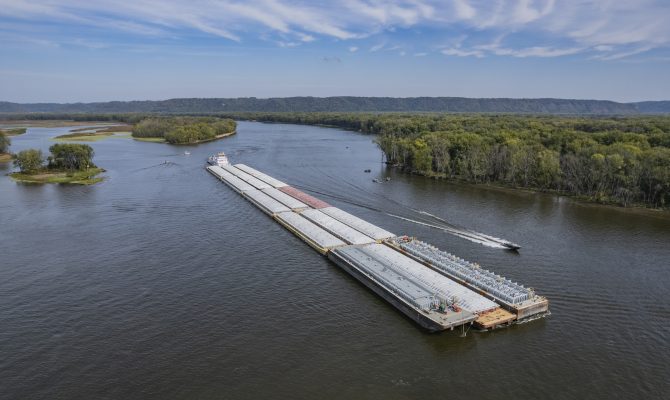
Barges and Tows
Don’t mess around with barges, towboats and tows. Towboat skippers are experienced, professional pilots. Still, they can only operate within the capabilities of their vessels. So, give them all the room possible; don’t flirt with disaster.
The typical tow consists of a towboat pushing 15 barges. It can be as large as 1,200 feet long, carry 18,000 tons and draw up to nine feet of water. Tows require most of the river in a sharp bend and need more than a mile to come to a full stop. Considering the corresponding characteristics of a motorboat, it’s obvious why the inland navigational rules clearly state that small craft must keep clear of them.
Pleasure craft should never cross the bow of a tow closer than 1,200 feet, as visibility from the pilothouse of a towboat is restricted by the barges. A blind spot of 1,133 feet exists beyond the front of empty barges, a little less on loaded barges. Needless to say, if your engine quits or if a water skier falls when you’re in the tow’s blind spot, there’s little the tow pilot can do.
Running close alongside tows is dangerous, too, since the boat’s propellers create suction that can trap a small boat and pull it up against the steel hull in an instant. The nine-foot-diameter props also put out huge volumes of water directly behind the towboat, and even the largest cruiser or houseboat may find it almost impossible to maneuver in this turbulence.
When meeting a tow at a bend in the river, be alert for “whistle signals” — usually communicated via VHF radio these days — that indicate the tow’s intention. “One whistle” or “on the one” means that the tow will pass on your port side; “two whistles” or “on the two” means it will pass on your starboard side. Downbound tows usually swing to the outside of a bend, running with the current in the deepest part of the channel. Upbound tows normally hop to the inside, favoring the slower water there.
Learn to recognize tows at night. The two amber towing lights at the stern of the towboat are in a vertical line. The amber light at the center of the tow on the bow flashes. It’s common practice among towboat pilots, upon sighting a pleasure boat at night, to turn on a searchlight momentarily. This is done to light up the bow of the tow to make it more easily seen.
Even moored barges, and other workboats, can be dangerous. Not only may there be lines beneath the surface running from anchors several hundred feet upstream, but there’s a current sweeping beneath the upstream end of those craft that could sweep you under.
Be careful and communicative with tows, and you have nothing to fear.
Editor’s note: For more information on Quimby’s Cruising Guide or to order, visit www.heartlandboating.com/Quimbys/.